Water Quality Report Card
The Mystic River and Wequetequock Cove Report Card grades the environmental health of our local coastal bays and harbors. It gets to the heart of a question we are asked all the time; specifically, “How is the water?” And that is an important question, however difficult it may be to answer succinctly. Our coastal waters are a vital environmental and economic resource.
Development of this report card was funded by the Long Island Sound Funder’s Collaborative, through the Long Island Sound Stewardship Fund, which is administered by the Long Island Community Foundation.
This report card builds on the methods used for the Unified Water Study Report Card efforts which began in 2017. With our long history of monitoring under the URI Watershed Watch program, back to 2008, we were able to apply the same grading methods used for the Unified Water Study to examine a longer time frame in this report card.

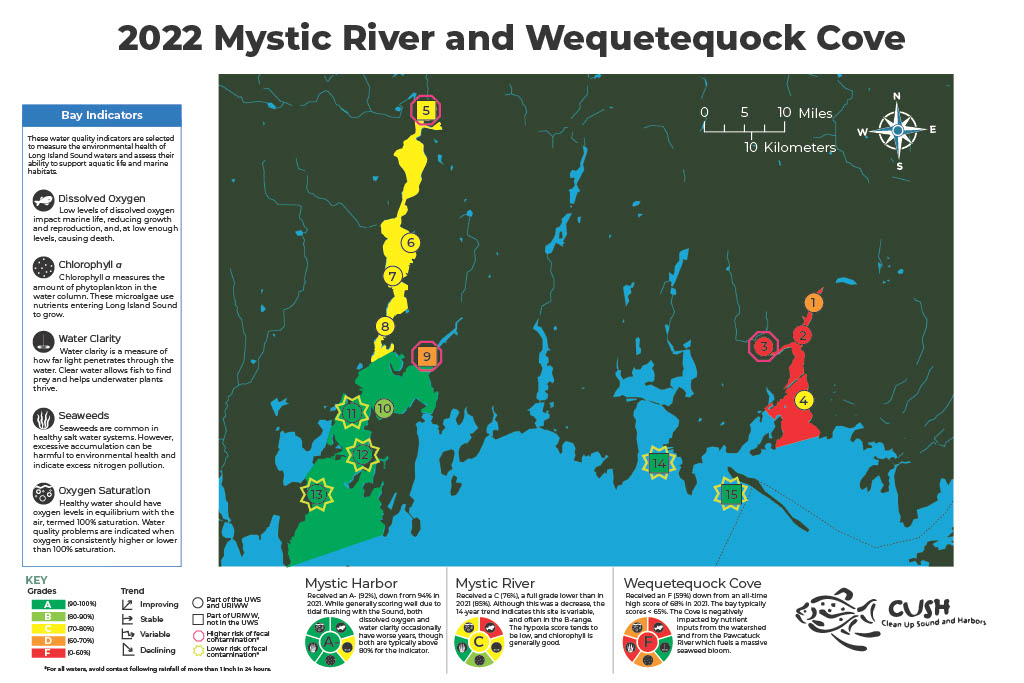
Let us start by looking at the 2022 grades. Starting in the west, or on your left, Mystic River received a C, denoted by the yellow color used to shade that portion of the embayment, while Mystic Habor receives an A-, denoted by the green area on the map.
This pattern tells a story of pollution and dilution in the Mystic area. The north to south gradient is created by our human footprint but also influenced by the natural geography of Mystic River as it transitions into Mystic Harbor. In general, places where our human population is concentrated brings nutrient-rich wastewater discharges from sewer and septic systems, as well as storm water runoff from hardened surfaces like roofs and roads into the coastal waters. In the inland zones of embayments, such as up in the northern reaches of the Mystic River, poor flushing with the Sound exacerbates water quality problems.
Wequetequock Cove illustrates an even more extreme example of water quality issues, receiving an F. Unlike Mystic Harbor which is flushed with relatively pristine waters from Fishers Island Sound, Wequetequock Cove is flushed with water from Little Narragansett Bay, which is experiencing its own water quality issues, though not denoted on this map. Nutrient-rich water exiting the Pawcatuck River enters Little Narragansett Bay and in turn, enters Wequetequock Cove. Coupled with nutrients and sediment coming from the local watershed, this source further impairs water quality in the Cove.
The grades are based on five indicators:
- chlorophyll-a, a measure of microscopic algae in the water,
- water clarity, a measure of how far light penetrates the water.
- dissolved oxygen, which is critical to the survival of fish and shellfish,
- oxygen saturation, a measure of whether the oxygen levels are too high, indicating a system out of balance, and
- seaweeds, which are common in healthy marine waters but excessive accumulation is a nuisance and can cause ecological problems.
These five indicators were combined into a score for each of the reporting regions. Those scores were compared to thresholds derived from scientific literature and management targets, leading to a grade. We used the same grading approach as applied by Save the Sound when grading the Unified Water Study data from 45 embayments around the Sound.
The other symbols on the map (red hexagons and green sunbursts) around most of the stations represent bacterial sampling. The hexagons, like a stop sign, indicate areas likely to have high levels of fecal contamination, with bacteria exceeding standards 30-60% of the time. The sunbursts indicate areas with an extremely low likelihood of fecal contamination, exceeding standards less than 1% of the time. And the remainder of the stations exceed allowable standards 5 to 20% of the dates sampled. Bacteria levels are an indicator of the impact on human health, or our ability to use the waters for recreation – times when we make contact with the water. In general, you want to avoid any waters for the day or two following a heavy rain of 1 to 1.5 inches over a 24-hour period – that rain washes bacteria into the coastal waters and can cause elevated bacterial levels.
In contrast, the report card grades the water quality in terms of the habitat health – the suitability of the water to support a vibrant community of plants and animals.

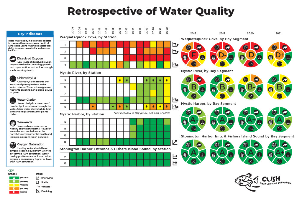
CUSH’s 15-year history of monitoring allows for a retrospective look at water quality in these embayments. The stations located in Fishers Island Sound and at the mouth of Stonington Harbor represent the best water quality our area could achieve – these areas have received A’s throughout the 15-year record and provide a yard-stick against which to measure our progress with improving water quality in Mystic and Wequetequock.
Mystic Harbor has received solid A’s for the last 5 years where all stations were monitored. The southern-most station in the Harbor, station 13 (Noank Village Boatyard), has a 15-year record which indicates improving water quality. In contrast, the station located in Mystic River with a 15-year record, station 8 (Mystic River Park) on the map, has been variable, receiving A’s and B’s, with a dip down into the C range in 2022. Over the last 5 years where all stations were monitored, Mystic River received B’s for most of that time period. Most of the stations in Wequetequock Cove have a longer history of monitoring and the trend is variable, with scores for the whole Cove in the D and F region.
While we have seen improvements over the last 15 years in Mystic Harbor, more work is needed in Mystic River and Wequetequock Cove. In addition, there are alarm bells ringing in the background as the impact of rising temperatures threatens to undo some of the great work that has been done. Rising water temperatures have a range of potentially damaging impacts on the marine environment including elevating the risk for hypoxia, or low levels of oxygen in the water. Put simply, the warmer the water, the less oxygen it can hold. We must remain vigilant and act.
While coordinated efforts are necessary to protect water quality throughout Long Island Sound and Fishers Island Sound, local action is necessary to protect the embayments like Mystic River, Mystic Harbor, and Wequetequock Cove. Water quality in bays is largely dictated by local factors. We cannot reliably predict the grade in any single bay using the grade in the neighboring reporting region of the Sounds – these shallow bays are impacted by more local pollutant sources on the neighboring land. When coupled with poor flushing, the water quality in these bays can be worse than in the open waters of the Sounds.
We know from historical accounts that the waters of Fishers Island Sound and Long Island Sound, including the western Sound and the shallow bays, were once bountiful and nearly pristine, supporting eelgrass meadows and thriving fisheries for oyster and menhaden. We have seen positive results in improved water quality resulting from investments such as sewage treatment upgrades and green infrastructure, therefore, we know that if we continue to commit the necessary resources and effort to the task, we will continue to make progress towards healthy conditions throughout our coastal waters —but it will require vigilance, persistence, and patience.
The back of the report card identifies actions you can take to reduce both water quality issues and bacterial contamination in our coastal waters.
If we maintain our dedication to monitoring and reporting, future report cards will track the progress we are making towards achieving that goal for ourselves and for future generations.
It is crucial that we continue to measure the water quality of our embayments on an ongoing and consistent basis – and report on the results so that action can be taken to protect and restore them.


